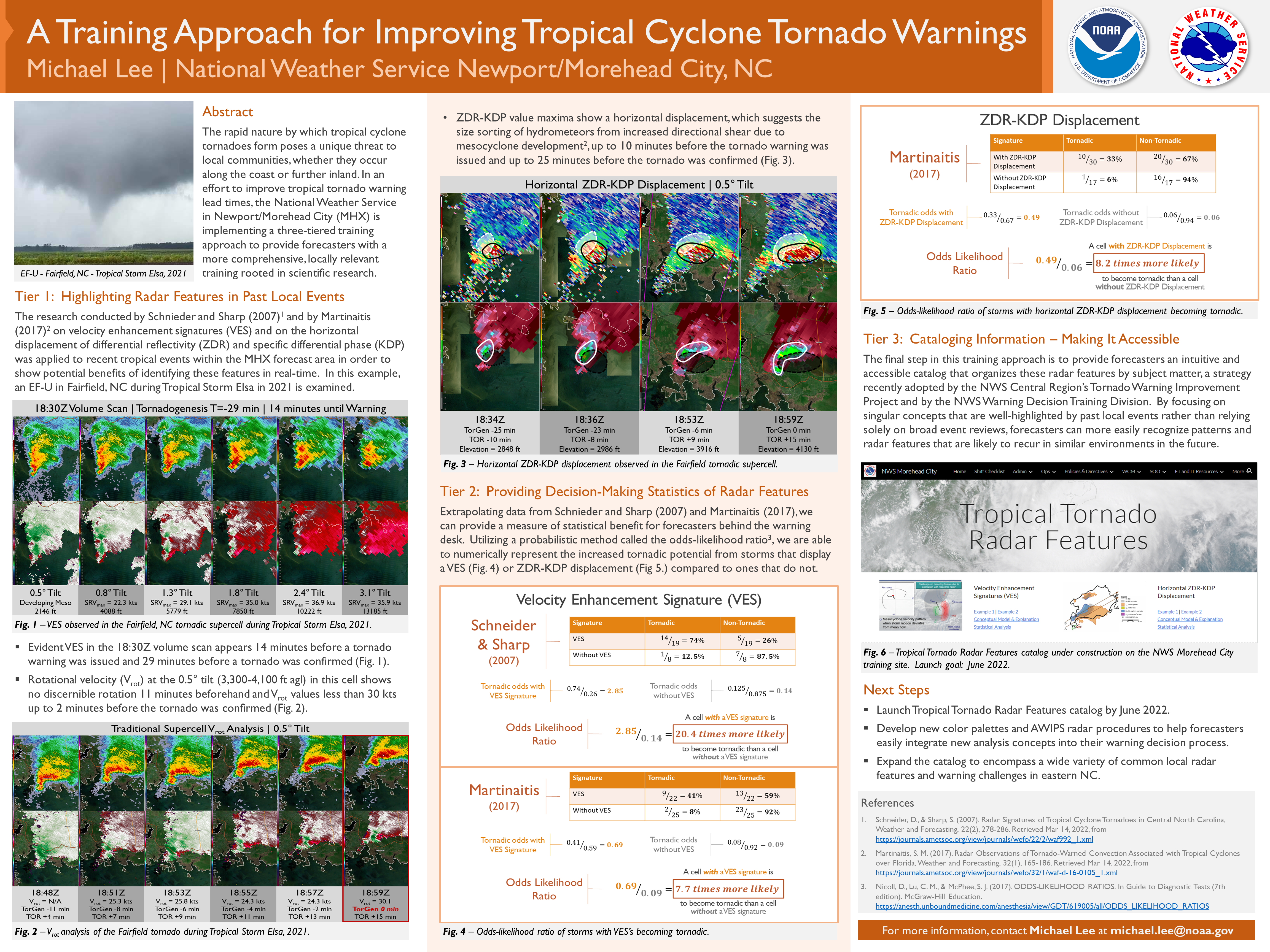
The rapid nature by which tropical cyclone tornadoes form poses a unique threat to local communities, whether they occur along the coast or further inland. In an effort to improve tropical tornado warning lead times, the National Weather Service in Newport/Morehead City (MHX) is implementing a three-tiered training approach to provide forecasters with a more comprehensive, locally relevant training rooted in scientific research.
Tier 1: Highlighting Radar Features in Past Local Events
The research conducted by Schnieder and Sharp (2007) and by Martinaitis (2017) on velocity enhancement signatures (VES) and on the horizontal displacement of differential reflectivity (ZDR) and specific differential phase (KDP) was applied to recent tropical events within the MHX forecast area in order to show potential benefits of identifying these features in real-time.
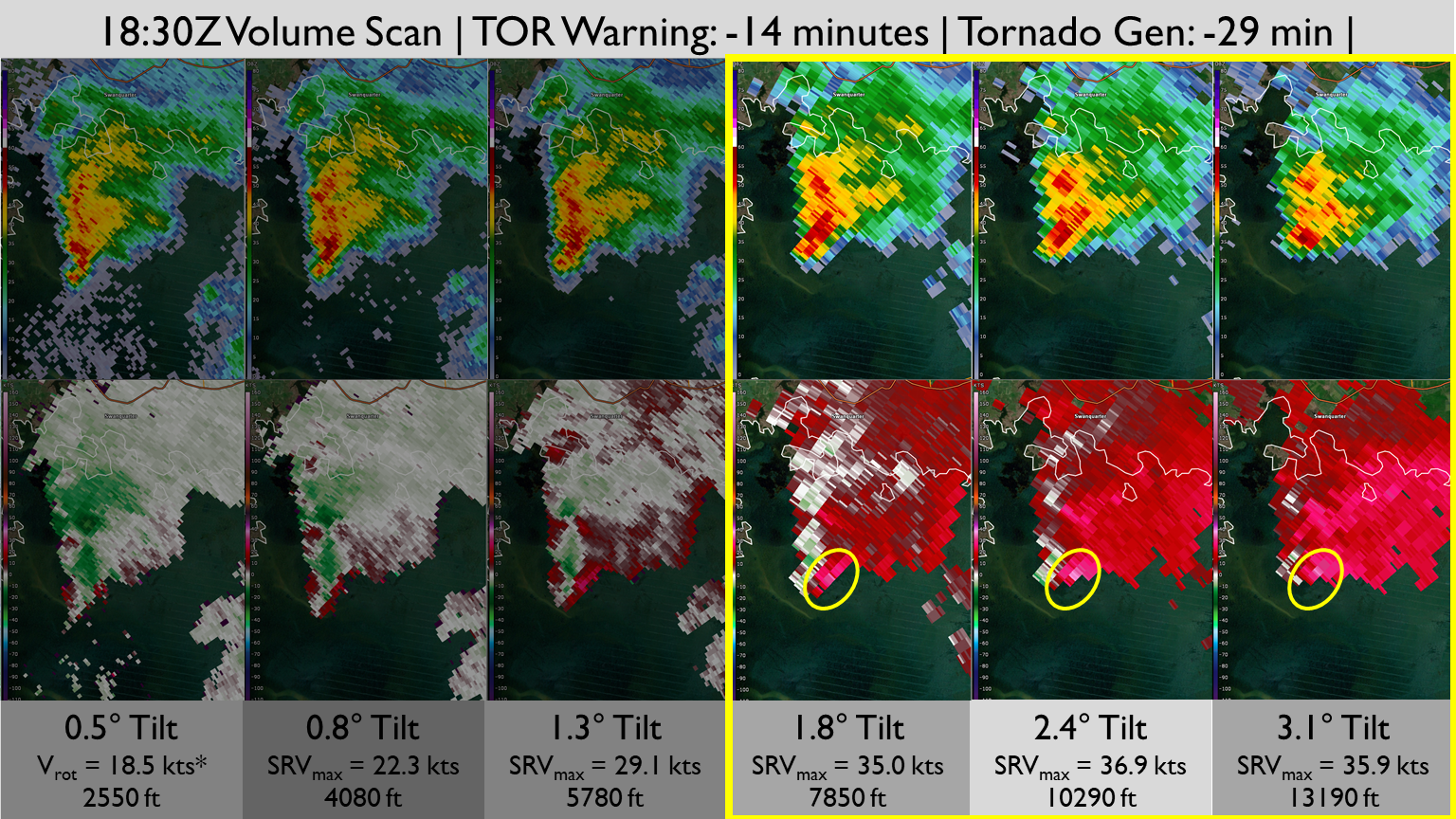
Reanalyzing the EF-U tornado in Fairfield, NC during Tropical Storm Elsa in 2021, and evident VES in the 18:30Z volume scan appears 14 minutes before a tornado warning was issued and 29 minutes before a tornado was confirmed (Fig. 1).
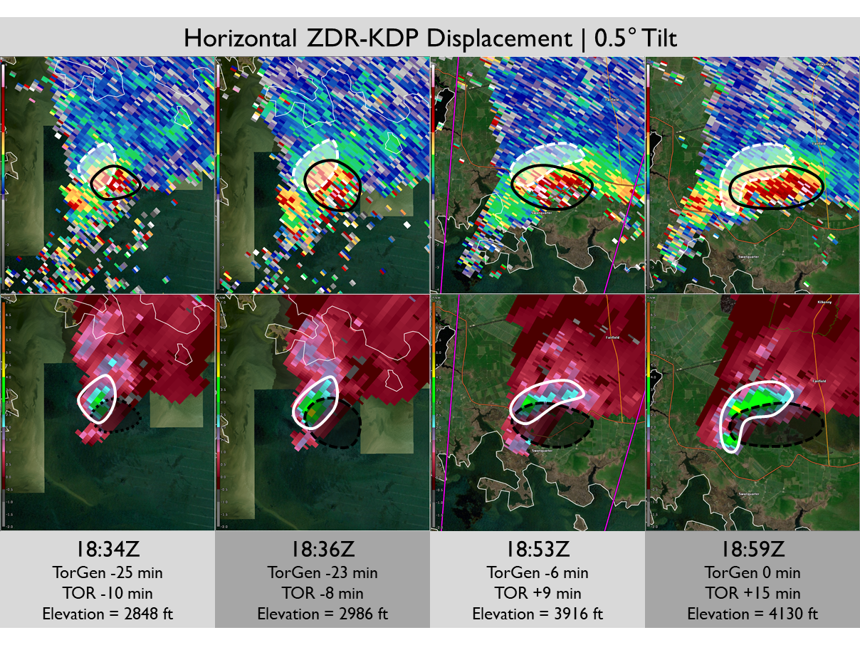
Additionally, ZDR-KDP value maxima show a horizontal displacement, which suggests the size sorting of hydrometeors from increased directional shear due to mesocyclone development, up to 10 minutes before the tornado warning was issued and up to 25 minutes before the tornado was confirmed (Fig. 2).
Tier 2: Providing Decision-Making Statistics of Radar Features
Extrapolating data from Schnieder and Sharp (2007) and Martinaitis (2017), we can provide a measure of statistical benefit for forecasters behind the warning desk. Utilizing a probabilistic method called the odds-likelihood ratio, we are able to numerically represent the increased tornadic potential from storms that display a VES (Fig. 3) or ZDR-KDP displacement (Fig 4.) compared to ones that do not.

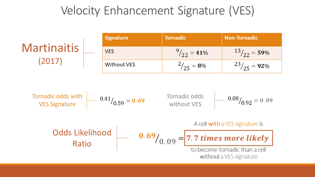
Fig. 3 – Odds-likelihood ratio of storms with VES’s becoming tornadic. 
Fig. 4 – Odds-likelihood ratio of storms with horizontal ZDR-KDP displacement becoming tornadic.
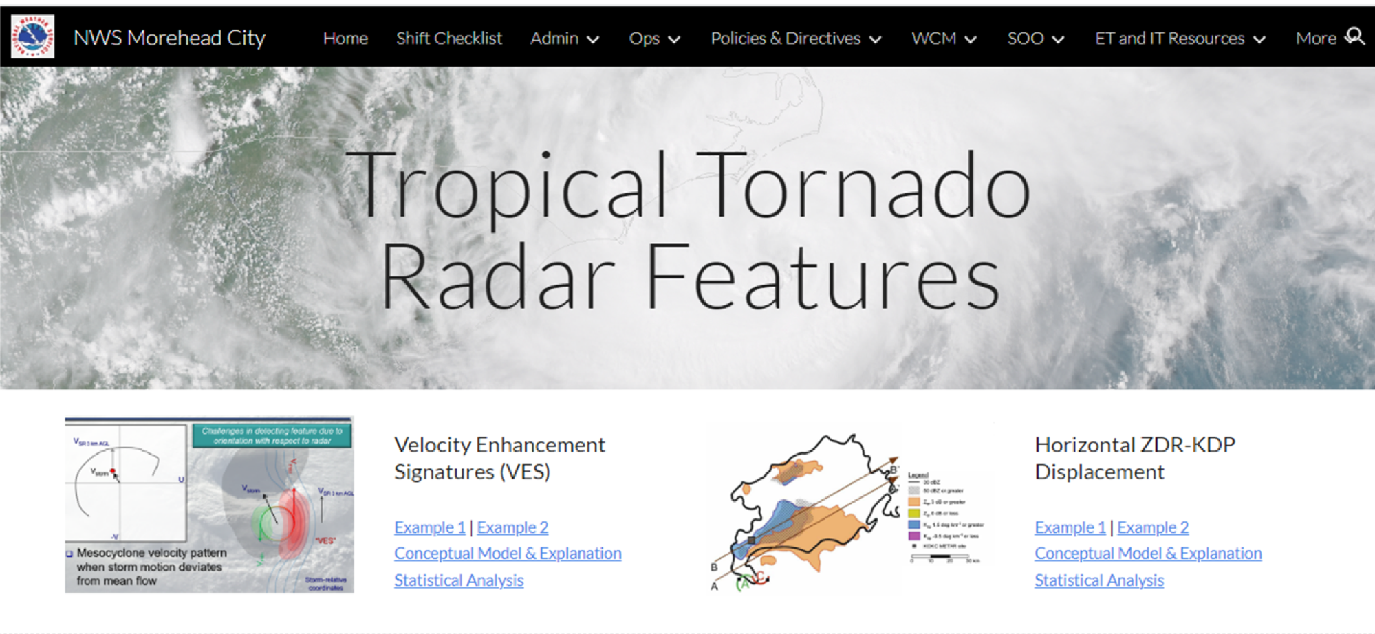
Tier 3: Cataloging Information – Making It Accessible
The final step in this training approach is to provide forecasters an intuitive and accessible catalog that organizes these radar features by subject matter, a strategy recently adopted by the NWS Central Region’s Tornado Warning Improvement Project and by the NWS Warning Decision Training Division. By focusing on singular concepts that are well-highlighted by past local events rather than relying solely on broad event reviews, forecasters can more easily recognize patterns and radar features that are likely to recur in similar environments in the future.
Next Steps
- Complete and launch Tropical Tornado Radar Features catalog by Summer 2022.
- Develop new color palettes and AWIPS radar procedures to help forecasters easily integrate new analysis concepts into their warning decision process.
- Expand the catalog to encompass a wide variety of common local radar features and warning challenges in eastern North Carolina.
References
- Schneider, D., & Sharp, S. (2007). Radar Signatures of Tropical Cyclone Tornadoes in Central North Carolina, Weather and Forecasting, 22(2), 278-286. Retrieved Mar 14, 2022, from https://journals.ametsoc.org/view/journals/wefo/22/2/waf992_1.xml
- Martinaitis, S. M. (2017). Radar Observations of Tornado-Warned Convection Associated with Tropical Cyclones over Florida, Weather and Forecasting, 32(1), 165-186. Retrieved Mar 14, 2022, from https://journals.ametsoc.org/view/journals/wefo/32/1/waf-d-16-0105_1.xml
- Nicoll, D., Lu, C. M., & McPhee, S. J. (2017). ODDS-LIKELIHOOD RATIOS. In Guide to Diagnostic Tests (7th edition). McGraw-Hill Education. https://anesth.unboundmedicine.com/anesthesia/view/GDT/619005/all/ODDS_LIKELIHOOD_RATIOS
