Tuesday, June 3rd
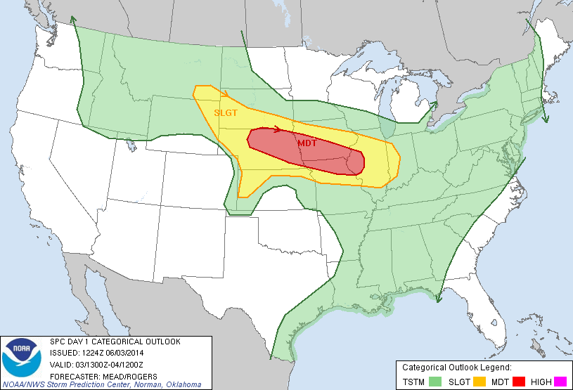
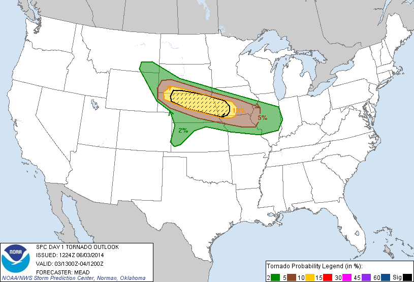
Today was forecasted to be the most intense chase day of the trip thus far. With high CAPE values, fantastic shear, plentiful moisture, and sufficient lift overlapping each other almost perfectly over northern Nebraska, one epic day was ahead of us. The SPC issued a Moderate Risk for an area stretching from northeast Nebraska, through the Iowa/Missouri border, and into west-central Illinois with a Significant Risk for tornadoes in northern Nebraska. If we were to see a tornado any day during this trip, today would be our best bet.
We began the chase in a town SE of Grand Island, NE (possibly Aurora? I don’t remember, a lot of things happened that day, alright?) to firstly get ourselves into a good position to intercept from the southern end of the cell, but secondly to also avoid a massive “chaser convergence” in Grand Island. Even Rutgers Meteorology Alumnus Jacob Carlin was amongst the chaser crowd in Grand Island! No, we weren’t trying to avoid him, we’re not that mean now. However, he was the talk of the town (well, at least in the RUchasing group) later in the day… I’ll explain later.
We moved another town north to Central City, NE to keep a closer eye on a cell forming just south of a massive cluster of storms to our north. While we waited, the SPC released their 20Z Day 1 Outlook, which put our location under a High Risk!

Although the tornado probability remained the same and the High Risk was issued as a result of a greater risk for straight-line winds, it was still exhilarating to be chasing in a High Risk area! Jacob was actually the one who notified us of our High Risk issuance first in addition to congratulating us in chasing in a High Risk region. Keeping close contact with Jacob when we could (sadly a cell signal does not settle well with Nebraska), he kept an even closer eye on the sky, or at least I did.
There was plenty of “agitated cumulus” observed by us, however nothing was coming to fruition as the HRRR model forecasted. However, while waiting at the park, we saw two DOW trucks (Doppler on Wheels) by Texas Tech drive by towards the storm to our north. This gave us hope that the cell we were looking at had good potential! Suddenly, a cell just south of the massive thunderstorm cluster went tornado warned and we were on our way to it!
On our pursuit to the cell, we received word that there was indeed a confirmed tornado on the ground, but that it was rain-wrapped. This spelled bad news for us because rain-wrapped tornadoes are impossible to see, which meant 1) we couldn’t view it from afar and 2) it was a very dangerous situation for anyone stuck inside that storm!
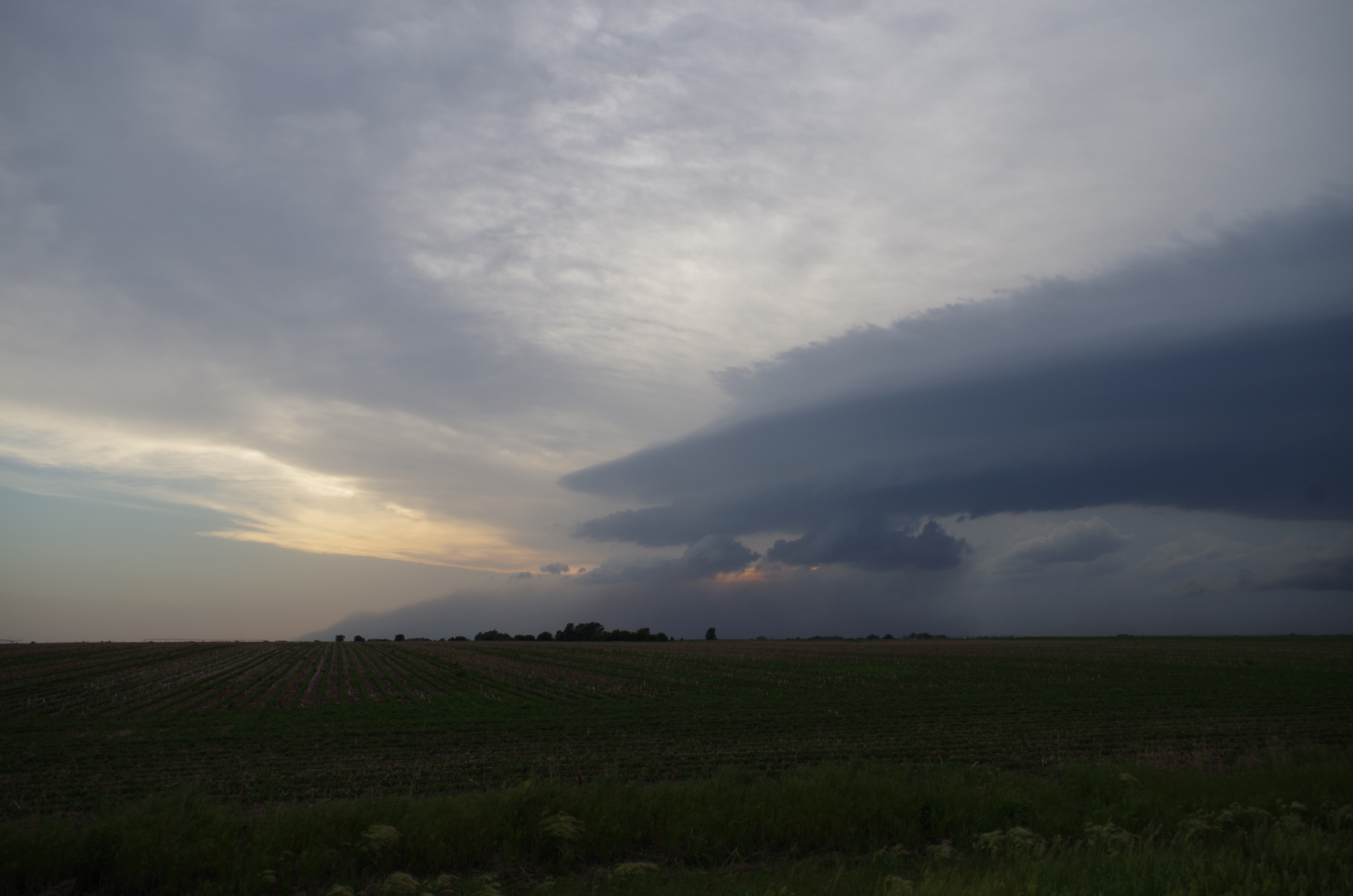
Upon reaching our viewing point, the storm was a beast. And to know that somewhere in there, out of sight, was a tornado was an eerie feeling.
We didn’t stay long – the storm was moving fast and right for our location. We booked it south then east to avoid the storm, but the drive was a rough one. This time, we got caught in the storm’s inflow. Intense winds were blowing towards the storm and trying to blow the vans off the road! Keeping a good hand on the steering wheel was an immense challenge as the winds whipped the vans back and forth along a narrow country road with 18-wheelers driving by you.
We took a quick stop before booking it south once again. At this point, the storm was very close to our location, and a rotating wall cloud greeted us at our viewing point.
Sadly, the video is quite shaky – holding a bulky DSLR without a tripod in whipping winds was a task to say the least. But if you put it in HD and look closely, you can see the wall cloud rotating rapidly, but also dust being kicked up near the surface. Hard to tell if that dust was rotating, but something sure was kicking it up!
Booking it south again, we stopped one last time to view the storm before leaving it for another cell to our south. At this point, the rotating wall cloud from before wasn’t spinning as violently as it was before.
Driving southward to a possibly more promising storm, we actually passed Sean Casey and the TIV 2 headed directly for the storm we deemed too dangerous to chase. Folks, if you’re storm chasing and you see the TIV or the Dominator in your area, assess where you are. You could A) be in a great position pursuing the right storm or B) be in deep doo-doo because you’re way too close to the storm!
On the road, we also found out that about 7 minutes after we left our initial viewing point of the storm that a rain-wrapped tornado was reported to have crossed the road right around where we were standing… Good thing we booked it out of there, right?
Upon intercepting our second target, we witnessed an amazing shelf cloud and the beginnings of an intense outflow boundary.
The outflow was helping feed the storm by lifting the warm, moist air right into the storm. In the video, you can literally see clouds forming and lifting into the storm cell as a result of the outflow!
Before we departed to escape the quickly advancing outflow, I had to do a nod to my other fandom – Doctor Who!

Yes folks, I collided my life passion for meteorology with my Doctor Who fandom into one awesomesauce picture!
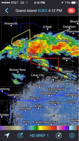
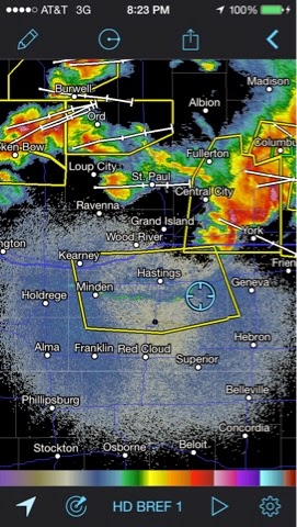
Enough of that, though, we had to book it! The NWS in Hastings issued a Severe Thunderstorm Warning just for the outflow coming our way. We passed by Hastings and not 4 minutes later, they measured an intense wind gust in excess of 70 mph! We literally missed it by a hair, which you can see on this radar image!
Calling it a day at a local Subway in the middle of nowhere, we got word from Jacob that he got caught in the same cell we were chasing. His car suffered some hail damage as he witnessed what he described as rotating sheets of rain around him. This just goes to show you that no matter how safe, intelligent, and experienced you are, mother nature can still catch you.
